
What is LiDAR and How Does it Work?
LiDAR (Light Detection and Ranging) is a remote sensing technology that uses laser pulses to measure distances and create highly accurate 3D maps. By sending out laser beams and analyzing the time it takes for them to return, LiDAR scanning generates detailed models of environments, structures, and objects.
LiDAR is widely used in industries like:
- Surveying
- Construction
- Forestry
- Restoration projects
- And, anywhere precision and efficiency are essential.
Need a high-accuracy scan for your project? Contact us for a free quote today.
LiDAR 101
The LiDAR scanning process involves three key components.
Laser Emission
A LiDAR scanner emits thousands of laser pulses per second toward a target.
Reflection and Detection
The laser beams hit surfaces and reflect back to the sensor.
Distance Calculation
The system calculates the time it took for the laser to return and determines the exact position of each point.
By collecting millions of these points, known as a point cloud, LiDAR creates a precise 3D representation of buildings or terrain. LiDAR can be mounted on drones, airplanes, or vehicles for aerial scanning or used in handheld and terrestrial systems for close-up measurements.
Types of LiDAR Scanning
LiDAR systems can be classified based on their application and platform.
Airborne LiDAR
- Mounted on drones, helicopters, or planes
- Used for topographic mapping and large-scale land surveying
- Creates highly accurate digital elevation models (DEMs)
Terrestrial LiDAR
- Ground-based scanning using stationary or mobile units
- Ideal for capturing details of buildings, infrastructure, and archaeological sites
- Provides high-resolution 3D models for construction and engineering projects
Mobile LiDAR
- Mounted on vehicles to scan roadways, urban environments, and landscapes
- Commonly used for transportation planning and city modeling
LiDAR vs. Photogrammetry: Key Differences
Both LiDAR and photogrammetry create 3D models, but they differ in technology and applications. Understanding their differences can help you choose the best method for your needs.
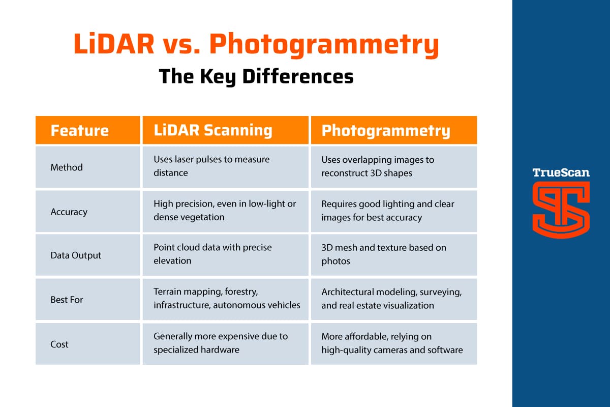
Method
- LiDAR scanning uses laser pulses to measure distances with extreme accuracy, making it effective even in low-light conditions or dense vegetation.
- Photogrammetry reconstructs 3D shapes using overlapping images, requiring good lighting and clear visuals for the best results.
Accuracy
- LiDAR scanning delivers high-precision measurements, ideal for detailed topographic surveys.
- Photogrammetry can achieve accurate results but depends on image quality and environmental conditions.
Data Output
- LiDAR scanning produces point cloud data with precise elevation details.
- Photogrammetry creates 3D mesh models with textures based on high-resolution photos.
Best Applications
- LiDAR scanning is widely used for terrain mapping, forestry analysis, infrastructure projects, and autonomous vehicle navigation.
- Photogrammetry excels in architectural modeling, land surveying, and real estate visualization, offering photorealistic 3D representations.
Cost Comparison
- LiDAR scanning typically requires specialized hardware, making it a higher-cost option.
- Photogrammetry is more budget-friendly, relying on high-quality cameras and advanced software.
Choosing the Right Technology
If your project demands high accuracy in challenging environments, LiDAR scanning is the superior choice. However, if you need visually rich, cost-effective 3D modeling, photogrammetry offers an accessible alternative.
Need expert guidance on LiDAR vs. photogrammetry for your project? Contact us today!
Applications of LiDAR Technology
Land Surveying and Mapping
LiDAR scans are widely used in geospatial applications, allowing surveyors, like TrueScan, to create highly detailed elevation maps for infrastructure projects.
Construction and Infrastructure
From monitoring job site progress to ensuring structural accuracy, LiDAR scanning provides precise 3D models that assist in construction planning.
LiDAR Scanning Services for Your Project
Looking for expert LiDAR scanning services? Our team specializes in high-accuracy LiDAR surveys for construction, mapping, and infrastructure projects.